Lake Information

Adam Lake

Light watercraft can gain access via the Rideau Canal System from Big Rideau Lake. Camping facilities, boat and cottage rentals are available at the lake. No public access from surrounding private land.
 

Click here to download a map of Adam Lake with directions.

Barbers Lake

Directions: From Highway 7 travel North on County Road 511. Turn left onto County Road 12 (McDonalds Corners Road). Turn left onto Highland Line and left again onto the 9th Concession A. There is a small unmaintained Launch off of the 9th Concession A Dal
 

Click here to download a map of Barbers Lake with directions.

Baxter Lake

Lake is surrounded by private land. Located due East of Highway #511, east of the Clyde River, at Dwyer Lane. No public access. Fish: Northern Pike, Pumpkinseed, Yellow Perch
 

Click here to download a map of Baxter Lake with directions.

Bi Rideau Lake

From County Road 1 (Rideau Ferry Road). Turn West on County Road 21 (Elm Grove Road). Follow signage to Murphy’s Point Provincial Park. Park fees required. Fish: Lake Trout, Lake Whitefish, Smallmouth Bass, Northern Pike, Walleye, Yellow Perch

Click here to download a map of Big Rideau Lake with directions.

Bob’s Lake

Directions: From Perth, head West on Highway #7. Turn left onto Glen Tay Road. Turn right onto County Road #6 (Christie Lake Road). Continue on to the Althorpe Road and across County Road #36 to Ritchie Side Road. Turn right on Crozier Road. There is curr

Click here to download a map of Bob’s Lake with directions.

Bow Lake

Directions: From Highway 7 head North on Highway 511. Turn right onto Bow Lake Road. Stay right onto Bow Lake Lane. Lake is surrounded by private land. No public access. Fish: Northern Pike, Pumpkinseed, Brown Bullhead, White Sucker.

Click here to download a map of Bow Lake with directions.

Boyd Lake

From Highway #7 head North on County Road #511. Turn left on County Road #16 (South Lavant Road). Boyd Lake is on the South side, just before 2nd. Concession, Dalhousie. Surrounded by private land. No Public Access. Fish: Northern Pike

Click here to download a map of Boyd Lake with directions.

Caldwell Lake

Directions: Located North West of Bottle Lake and South of Lavant Station. Unknown access. South half of lake is surrounded by private land. North half is surrounded by County Forest. Canoe access may be possible from North end of Bottle Lake via creek

Click here to download a map of Caldwell Lake with directions.

Clyde Lake

Directions: From Highway #7 travel North on Highway #511. Turn left onto the French Line Road. Continue on the French Line Road to Lavant Darling Road. At the village of Joes Lake, turn right onto the Flower Station Road to the K&P Trail. Head East on the

Click here to download a map of Clyde Lake with directions.

Dalhousie Lake

Directions: Leave Highway 7 at Perth and travel North on County Road 511 to the village of Balderson. At Balderson, turn onto County Road 7 (Fallbrook Road) and follow it west and then north for 9 km (5.6 miles) to the intersection of County Roads 7 and 1

Click here to download a map of Dalhousie Lake with directions.

Davern Lake

Directions: Head West from Perth on Highway #7 to County Road #36 at Maberly. Head South on County Road 36 for approximately 15km to the Davern Lake area. Lake is surrounded by private land. No public access. Fish: Smallmouth Bass, Pike, Perch, Pumpkinse

Click here to download a map of Davern Lake with directions.

Doctor Lake

Lake is located South of County Road #10(Scotch Line) off Otty Lake Sideroad – past Wildlife Road on the left hand side (East). Fish: Banded Killfish, Bluegill, Northern Pike, Pumpkinseed, Yellow Perch.

Click here to download a map of Doctor Lake with directions.

Farren Lake

Directions: Farren Lake is situated approximately 7 miles south of the village of Maberly at Highway #7. Follow County Road 36 through Bolingbroke to where the road borders the east end of the lake. A short portage over the township road allowance is prov

Click here to download a map of Farren Lake with directions.

Graham Lake

Fish: Northern Pike, Walleye, Brown Bullhead, Rock Bass.

Click here to download a map of Graham Lake with directions.

Hogg Bay/Big Rideau/Loon Lake Loop

How to get there: Six km south of Perth on County Rd. 1 to County Rd, 21. Turn towards Murphys Point Provincial Park, 12 km. Launch Site: The main beach on Hogg Bay. Site fees apply. The Paddle: Recommended direction for prevailing winds from the west. Pa

Click here to download a map of Hogg Bay/Big Rideau/Loon Lake Loop with directions.

Joe’s Lake

Directions: From County Road 511, turn left onto French Line Road. Continue left onto Lavant Darlig Road. Stay on Lavant Darling Road (past Campbell’s Road) and turn right onto Flower Station Road. The boat launch is on the left, slightly hidden & acros

Click here to download a map of Joe’s Lake with directions.

Kerr Lake

Directions: From Perth, take Hwy. 511 to Clydesville. Entrance is not marked – before Clyde River bridge. Fish: Northern Pike, Walleye, Largemouth Bass, Yellow Perch, White Sucker, Bullhead.

Click here to download a map of Kerr Lake with directions.

Lavant Lake

Lake is surrounded by private land to the North East and Crown Land on the South West. There are no marked trails for Crown Land access.

Click here to download a map of Lavant Lake with directions.

Little Green Lake

Fish: Yellow Perch, White Sucker, Proposed to restock with Brook Trout

Click here to download a map of Little Green Lake with directions.

Little Silver Lake

Directions: From Perth take Cty. Road 6 (Christie Lake Rd.) to Althorpe Road and continue towards the Bolingbrooke Road. Suitable for small motorized craft and car top. No camping. Fish: Lake Trout, Northern Pike, Smallmouth Bass, Yellow Perch, Rock Bass,

Click here to download a map of Little Silver Lake with directions.

Lower Rideau Lake

Directions: From Perth, take Hwy. 43 to Port Elmsley. Immediately outside the village you will see a field entrance on the south hand side. Follow through fields to back of property. There is also a launch located at Beveridge Locks off of Beveridge Locks

Click here to download a map of Lower Rideau Lake with directions.

MacKay Lake

Located between the villages of Middleville and Tatlock. Lake is surrounded by private land, East of Darling Road and North of Galbraith Road. No public access.

Click here to download a map of MacKay Lake with directions.

Mann Lake

Located East of the village of Flower Station. Lake is surrounded by private land. No public access.

Click here to download a map of Mann Lake with directions.

McLarren Lake

Lake is surrounded by private land West of Otty Lake. Access by canoe or small watercraft from Otty Lake only. Fish: Alewife, Black Crappie, Brown Bullhead, Burbot, Largemouth Bass, Minnows, Northern Pike, Pumpkinseed, Rock Bass, Smallmouth Bass, White S

Click here to download a map of McLaren Lake with directions.

Murray Lake

Located past the end of 5th Conc. Darling. Lake is surrounded by private land. No public access. Fish: Lake Trout, Brook Trout, Perch, Sucker, Pumpkinseed, Minnow Species

Click here to download a map of Murray Lake with directions.

Nicholson Lake

Small lake located Southwest of the village of Clyde Forks, just West of the K&P Trail. No known public access point.

Click here to download a map of Nicholson Lake with directions.

Paddy Lake

Directions: Take Highway #511 North of Lanark past the village of Hopetown. Head West on County Road #16 (South Lavant Road). At the village of Poland, continue West on Umpherson’s Mill Road. Turn right onto Ranger Camp Road and follow this road around

Click here to download a map of Paddy Lake with directions.

Patterson Lake

From Highway #511, North of Lanark, head West on County Road #8 (Watsons Corners Road). Turn right to head North on 5th Concession B Dalhousie, to the South East corner of the lake. The lake is mostly surrounded by private land. No public acces Angling s

Click here to download a map of Patterson Lake with directions.

Peterwhite Lake

Located East of Highway #511, between New Road and Radley, Lane. The lake is just North of a three-tower Hydro line. Private land surrounds the West half of the lake. The East half of the lake has Crown Land access, with unmarked trails, from the North si

Click here to download a map of Peterwhite Lake with directions.

Pike Lake

From Perth, head South West on County Road #10 (Scotch Line) past Stanleyville Road, to Civic #4205. Public launching ramp and parking area are located at the North East end of the lake near the retaining dam on Grants Creek. A commercial trailer park and

Click here to download a map of Pike Lake with directions.

Robb’s Lake

Directions: Located just North of the village of Tatlock, between 7th Concession Darling and Caldwell Lane. Lake is surrounded by private land. No Public Access.

Click here to download a map of Robb’s Lake with directions.

Samuel Lake

Located South of Tatlock Road and West of Darling Road. Lake is surrounded by private land. Crown Land parcel at the Southern end of the lake is also surrounded by private land. No Public Access. Fish: Northern Pike, Br. Bullhead, Pumpkinseed, Rock Bass,

Click here to download a map of Samuel Lake with directions.

Tate Lake

Directions: Located South of the Village of Lavant and South East of Paddy’s Lake. No known Public Access. Fish: Brown Bullhead, Northern Pike, Minnows

Click here to download a map of Tate Lake with directions.

Upper Mud Lake

Fish: Northern Pike, Pumpkinseed, Yellow Perch

Click here to download a map of Upper Mud Lake with directions.

White Lake

How to get there: From Perth, take County Rd. 511 almost to edge of Lanark County. Watch for boat launch sign at White Lake Rd. Go 1.4 km to 3-way split. Take left fork onto Walabec Rd. 0.9 km, then turn right onto Walabec Side Rd., then 0.2 km to boat la

Click here to download a map of White Lake with directions.

Andrew Lake

Located North of Otty Lake. Lake is surrounded by private land North of Kenyon Road and McLaren Road. No Public Access. Fish: Central Mudminnow
 

Click here to download a map of Andrew Lake with directions.

Bartraw Lake

Details: South half of lake is surrounded by private land. North half is located North of the County line. No Public Access is known. Fish: Northern Pike, Smallmouth Bass, Yellow Perch, Pumpkinseed, White Sucker
 

Click here to download a map of Bartraw Lake with directions.

Bennett Lake

From Perth, take Highway #511 North to Balderson. Turn west on Fallbrook Rd. (County Rd. #7) and follow this road west then north, to the village of Fallbrook. Turn west on Bennett Lake Rd. (County Rd. #19). Turn South on Ennis Rd. Follow this road to the
 

Click here to download a map of Bennett Lake with directions.

Black Lake

To reach Black Lake from Perth take County Road 10 (Scotch Line) to the Narrows Lock Road for access to South Side of the Lake. To access the North side continue on County Road 10 to the Stanleyville Road, follow straight through onto the Black Lake Road.
 

Click here to download a map of Black Lake with directions.

Bottle Lake

Directions: From Highway 7, head North on County Road 511. Turn left on County Road 16 (South Lavant Road). Turn left onto Bottle Lake Road. Access at the end of Road for small motorized and cartop watercraft. Fish: Brook Trout, White Sucker, Brown Bull
 

Click here to download a map of Bottle Lake with directions.

Bower Lake

Directions: From Highway 7 head North on County Road 511. Turn left on County Road 8 (Watsons Corners Road). Turn right on 8th Concession Dalhousie. Continue on Umphersons Mill Road South. Turn left onto Ranger Camp Road. Access for Bower will be on the L
 

Click here to download a map of Bower Lake with directions.

Bradford Lake

Click here to download a map of Bradford Lake with directions.

Christie Lake

Directions: To reach Christie Lake follow County Road #6 from Perth for 8.5 miles (13.5 km). Turn right on Christie Lake North Shore Road and follow signage to private launching facilities. Resort signs to Christie Lake are located along the road. Boat la
 

Click here to download a map of Christie Lake with directions.

Connors Lake

Directions: From County Road 511, turn west onto County Rd #16 (South Lavant Rd.). Connors Lake is North West of the village of Poland and West of Black Creek Road. Lake is surrounded by private land. No public access. Fish: Northern Pike
 

Click here to download a map of Connors Lake with directions.

Darling Long Lake

From Highway #7, head north on County Road #511. Turn east, opposite Little Green Road. Follow tertiary road to remote camping and cartop / small craft site at Lot 21, Concession V1, Darling Township. Natural shoreline used as launch. Fish: Northern Pik
 

Click here to download a map of Darling Long Lake with directions.

Dixon Lake

Directions: Take Highway #511 North from Perth to County Road #16 (South Lavant Road). Travel West, past the village of Lavant and turn left onto Bottle Lake Road. Take the first left tertiary Road off Bottle Lake Road and follow to Dixon Lake. This natur
 

Click here to download a map of Dixon Lake with directions.

Duncs Lake

Directions: Small Crown land lake located Northwest of Tatlock. A series of forest access roads and trails off 6th Concession, Darling, North of Tatlock Road, lead to this fairly remote location Northwest of the Indian River Crossing. Access may be restri
 

Click here to download a map of Duncs Lake with directions.

Gillies Lake

Fish: Northern Pike, Walleye, Brown Bullhead, Ling, Perch, Rock Bass, White Sucker
 

Click here to download a map of Gillies Lake with directions.

Green Lake

Fish: Speckled Trout
 

Click here to download a map of Green Lake with directions.

Horne Lake

Fish: Northern Pike, Walleye
 

Click here to download a map of Horne Lake with directions.

Kates Lake

Crown Land Lake located Northwest of Tatlock. A series of forest access roads and trails off Con. Road 6, North of Tatlock may lead to this remote area. Fish: Brook Trout, Sucker
 

Click here to download a map of Kates Lake with directions.

La France Lake

Lake is north of the village of Lavant and South of Triple Tower Road. Access from North side of lake is private land. The South side of the lake is surrounded by Crown Land although road access is not marked. Fish: Northern Pike, Walleye, Sm Bass, Br. Bu
 

Click here to download a map of La France Lake with directions.

Lavant Long Lake

Lanark Highlands fishing guide available at the Township Office, 75 George Street in Lanark Village.
 

Click here to download a map of Lavant Long Lake with directions.

Little Joe Lake

Lake is located North East of Joe’s Lake and surrounded by private land. No public access.
 

Click here to download a map of Little Joe Lake with directions.

Long Lake

How to get there: South from Perth on County Rd. 1 towards Rideau Ferry to County Rd. 21. Turn towards Murphys Point Provincial Park. Turn right at Long Lake Rd. (see sign for Scout Camp) and travel 3 km. Launch Site: RVCA launch site on left. The Paddle:
 

Click here to download a map of Long Lake with directions.

Lowney Lake

Directions: Head North on County Road 29. Turn left onto Cedar Hill Side Road. Turn right on 6th Con. Pakenham and then a left onto Bellamy Road. Stay left on Bellamy Road to continue onto County Road 24 (Peneshula Road). At Y in the road stay right conti
 

Click here to download a map of Lowney Lake with directions.

Madden Lake

Located between the villages of Clayton and Tatlock, North of Halls Mills. Lake is surrounded by private land. No public access.
 

Click here to download a map of Madden Lake with directions.

McGowan Lake

Fish: Largemouth Bass, Northern Pike, Smallmouth Bass, Br. Bullhead, Pumpkinseed
 

Click here to download a map of McGowan Lake with directions.

Mississippi Lake

Directions: Public access is gained by the use of the boat-launching ramp in the Municipal Park in Carleton Place on Lake Avenue West. A second launch is located off of Drummond Concession 9A. There are other boatlaunching facilities supplied by commercia
 

Click here to download a map of Mississippi Lake with directions.

Napier Lake

Directions: From Highway #511 turn West onto Campbell’s Road. Crown land may provide unmarked access trails to this lake from the South. Fish: Brook Trout, Lake Trout
 

Click here to download a map of Napier Lake with directions.

Otty Lake

Directions: Located South of the Town of Perth. From County Road #1 (Rideau Ferry Road) head South West on County Road 21 (Elmgrove Road). Turn right on Miller Bay Road and continue 1 km to public launch site at the South West end of the lake. Parking i
 

Click here to download a map of Otty Lake with directions.

Park Lake

Directions: From Hwy. 511, take County Road 16, South Lavant Road, then Umphersons Mill Road South to Ranger Camp Road. Fish: Yellow Perch, Pumpkinseed, Pike, Walleye. The Paddle: Circumnavigate the lake. Keep track of directions for you can get lost in m
 

Click here to download a map of Park Lake with directions.

Perch Lake

Directions: Take the forest access road north from the abandoned K&P railway at Clyde Forks a distance of approximately 2 miles. The remainder of the road is recommended only for four wheel drive, all terrain vehicles or walking. Fish: Rainbow Trout (stoc
 

Click here to download a map of Perch Lake with directions.

Pigeon Lake

Located North East of the village of Lavant. Access may be provided from the County Forest along the South Western Shoreline. Access through Crown Land is unknown. The North East portion of the lake is surrounded by private land.
 

Click here to download a map of Pigeon Lake with directions.

Reid Lake

Directions: Located East of Darling Road and South of Tatlock Road. Lake is surrounded by private land. No Public Access. Fish: Largemouth Bass, Perch, Pumpkinseed
 

Click here to download a map of Reid Lake with directions.

Rock Lake

Located North of Long Lake Road, West of Otty Lake. Lake is surrounded by private land. No Public Access Fish: Largemouth Bass, Northern Pike, Yellow Perch, Pumpkinseed, Bluegill
 

Click here to download a map of Rock Lake with directions.

Rock Lake

Located North of Long Lake Road, West of Otty Lake. Lake is surrounded by private land. No Public Access Fish: Largemouth Bass, Northern Pike, Yellow Perch, Pumpkinseed, Bluegill
 

Click here to download a map of Rock Lake with directions.

Silver Lake

Directions: Located just North of Highway #7, approximately 5 km West of the village of Maberly. Access is available at Silver Lake Provincial Park, (Provincial Park fees apply). There is also a free gravel access point on the North side of Highway #7, le
 

Click here to download a map of Silver Lake with directions.

Taylor Lake

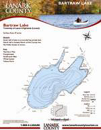
Fish: Northern Pike, Largemouth Bass, Yellow Perch, Brown Bullhead, White Sucker, Pumpkinseed, Rock Bass How to get there: From Almonte, take County Rd. 16 (Wolf Grove Road) 12 km to Lanark Conc. 12. Turn north. Launch Site: End of road. The Paddle: Ci
 

Click here to download a map of Taylor Lake with directions.

Upper Rideau Lake

Directions: The Upper Rideau Lake is located 60 km North of Kingston at the village of Westport. It can also be reached by watercraft via the Rideau Canal System through a series of locks from either the Big Rideau Lake, Lower Rideau Lake or the Rideau Ri
 

Click here to download a map of Upper Rideau Lake with directions.